

Norway, with its dramatic fjords, towering mountains, and untouched landscapes, is a hiker’s paradise. From the rugged coastline of the Lofoten Islands to the snow-capped peaks of Jotunheimen National Park, this Scandinavian gem offers some of the most breathtaking hiking experiences in the world.
In this blog post, we’ll be sharing our 10 favourite Norwegian hiking trails that offer the most beautiful and unique views throughout the country. From deep blue fjords, lush valleys dotted with waterfalls and arctic beaches, Norway has something for every hiker, regardless of skill level.
1. Reinebringen Hike in the Lofoten Islands
DISTANCE
2 km (round trip)
ESTIMATED TIME
2 hours
ELEVATION GAIN
448 m
DIFFICULTY
Moderate
One of our favourite hikes in Norway and definitely one of the most Instagrammed is Reinebringen in the Lofoten Islands. Known for its panoramic views of fishing villages, vast mountains and majestic fjords, it’s a hike that will take your breath away (literally and figuratively).


Reinebringen is a short but steep trail, with 1566 sherpa steps to the summit and an elevation gain of 448m. The trail is relatively easy, but it’s definitely a fitness challenge and requires a solid level of endurance. Once you reach the top, the path does become muddy and rocky, and has some exposed sections.
The trailhead is located along the western side of the E10 road that passes by Ramsvik tunnel. You’ll see a yellow warning sign next to some steps going up into the trees, this is where the hike starts. We recommend you park in the Djupfjord viewpoint car park, as it’s the largest free carpark in the area and a 1.3km walk to the trailhead.
2. Segla and Hesten Hike in Senja
DISTANCE
5 km (round trip)
ESTIMATED TIME
2-3 hours
ELEVATION GAIN
512m
DIFFICULTY
Moderate
Segla is one of the most scenic hikes in Norway, with an incredible jagged rock face that dramatically plunges vertically to the fjords below. We highly recommend this one, as it has some of the most photogenic views we have ever seen.
The trail starts off relatively easy with a small incline, and soon after the path becomes rocky and uneven, and gets steeper as you make your way up the mountain. The trail weaves through birch woodland and then opens up to more rocky terrain. The trail isn’t too demanding, and is rated a medium difficulty by Norwegian standards.

If you’re after the iconic view of Segla, shown in the picture, you’ll want to head in between the two mountains Segla and Hestern. Once you reach the saddle, instead of continuing on to climb the final steep rocky path, head inwards towards the Segla rockface. There are multiple paths, and it’s a bit of a scramble through grass and rocks, but it’ll lead you to the edge of the mountain, with Segla proudly standing in front of you. However, take extreme care as this is a cliff with a vertical drop.
There are two different trailheads, one for Segla and one for Hesten. We parked at the Hesten Trail head, as this was the route for the best view of Segla. The trail is located in upper Fjordgård, but has no official name. This is the address: ‘Unnamed Road 9388, Fjordgård, Norway’.
3. Innerdalen Valley Walk in Western Norway
DISTANCE
7 km (round trip)
ESTIMATED TIME
2 hours
ELEVATION GAIN
300 m
DIFFICULTY
Easy
Often labelled as the most beautiful valley in Norway, Innerdalen Valley is a hidden gem located in the breathtaking landscapes of Western Norway. This is a family friendly hike in Norway that offers picturesque views of Innerdalstårnet mountain towering above a calm lake, waterfalls and rustic grass-roofed cabins. The majestic scene makes you feel like you’re in Lord Of The Rings Movie!


The walk to Innerdalen valley is an easy 3.5km gravel road, with a small bit of incline to get your heart racing. Once you’re in the valley, you can visit Renndølsetra and Innerdalshytta, a cafe serving waffles, pastries and hot drinks, and cabins you can stay in. However, it’s worth noting these are only open during the summer months. You can also do more hikes that start in Innerdalen Valley, such as the Innerdalen to Renndølsetra trail.
The trailhead for Innerdalen Valley starts at Nerdalen/Innerdalen Parking. To reach this, drive along the RV70 road, located between Kristiansund and Sunndalsøra. Once you reach Ålvundeid, turn off on the north side of the road and follow the road until you reach the parking.
4. Mannen Hike in the Lofoten Islands
DISTANCE
3.5 km (round trip)
ESTIMATED TIME
2-3 hours
ELEVATION GAIN
400 m
DIFFICULTY
Moderate
Earning its spot in our top picks of Norway’s hiking trails, the Mannen hike in the Lofoten Islands stands out as a favourite, with panoramic views of the surrounding mountains and expansive ocean. On a sunny day, the view of turquoise waters and pristine white sand, set against the backdrop of rolling green fields, might easily deceive you into believing you’re on a tropical island, not deep in the arctic circle.

The trail itself is a steady climb to 400m, passing through gravel road and into a zig zag path through the grass. There are a few scrambly sections along the way, but nothing too difficult. Once you reach the summit, the path becomes rocky and muddy, and has some exposed sections.
The trailhead for Mannen begins at Haukland Beach Parking. Once you’ve parked, cross the road and head up the gravel path that follows the mountain. There are a couple of different paths from here, some are steeper as they cut through the mountain, and others are longer as they wind around.
5. Kvalvika Beach and Ryten Hike in the Lofoten Islands
DISTANCE
7 km (round trip)
ESTIMATED TIME
3 hours
ELEVATION GAIN
543m
DIFFICULTY
Moderate
Only accessible by foot, Kvalvika Beach is an isolated bay on the island Moskenesøy, with dramatic mountains rising from the golden sand beach and turquoise arctic waters. Overlooking Kvalvika Beach stands Ryten, with panoramic views of the surrounding mountains, incredible photo opportunities and a captivating “mini Trolltunga” rock formation jutting from the mountainside.
There are a couple of different hiking routes for Kvalvika Beach and Ryten, you can opt to hike directly to Ryten, with the option to descend to the beach, or start at Kvalvika Beach and ascend to Ryten from there. The trail to Kvalvika Beach is an easy hour-long walk with a gentle incline. While the initial path may be boggy, wooden walkways help to avoid this. The path eventually becomes grassy and rocky, with a scrambly rock decent to reach the beach

For those following the Ryten trail, expect a similar path with more incline and exposed sections. Although parts of the trail may be steep, it’s fairly manageable and it’s categorised as an easy hike by Norwegian standards.The trailheads are located at Innersand Parking and Kvalvika Beach Trail Head. We parked at Kvalvika Beach, but it’s worth noting there’s only space for approximately 20 vehicles, so you’d have to arrive early to park here.
6. Litlefjellet Hike in Western Norway
DISTANCE
2 km (round trip)
ESTIMATED TIME
1 hour
ELEVATION GAIN
140m
DIFFICULTY
Easy
Hidden away in the mountains of Western Norway is Mount Litlefjellet, a hidden gem of a hike that has incredible views of the Trolltindene mountains and trollveggen Cliff, also known as ‘the Troll Wall’, which is the tallest vertical rock face in Europe, standing at 1100m. Not only does it have views over the lush green valley below, but there is a still tarn that perfectly mirrors the mountain peak, creating an epic photo opportunity.


The trail to Litlefjellet is short but steep, and only takes roughly 30 minutes to reach the top, with an elevation gain of 140m. The trail takes you up the side of the mountain, so there’s a little bit of scrambling where you’ll need to use your hands to help you up; but this is minimal and it’s still rated as easy.
The trailhead starts at the base of Litlefjellet, in the Venjedalen valley. It’s only accessible by car and is approximately 40 km from the nearest town of Åndalsnes. You’ll pass a toll booth where you have to pay a fee of 100 NOK (card accepted), and then follow a steep gravel road that winds its way up the valley. You’ll reach a point where you can see the sign for the Litlefjellet Hike.
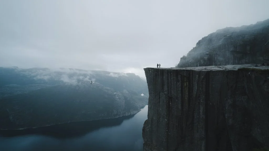
7. Preikestolen Hike in Western Norway
DISTANCE
8 km (round trip)
ESTIMATED TIME
4 hours
ELEVATION GAIN
500m
DIFFICULTY
Moderate
The Preikestolen hike, also known as the Pulpit Rock, is an iconic and breathtaking trail located in Western Norway. The trail leads to an enormous cliff, which stands 604m above the Lysefjorden fjord. From this vantage point, you have panoramic views of Norway’s fjords, mountains and deep blue waters.
The trail covers a distance of roughly 8 km and takes approximately 4 hours to complete, passing through a variety of terrains such as wooden walkways and forest areas. There are a few steep sections, but it’s generally a gentle climb to 500m, and is rated as medium difficulty by Norwegian standards.
The trailhead for the Preikestolen hike begins at the parking area near the Preikestolhytta Mountain Lodge in Forsand, and costs 250 NOK to park for the day. From here, the trail is well-marked and easily accessible.
8. Trolltunga Hike in Western Norway
DISTANCE
27 km (round trip)
ESTIMATED TIME
10-12 hours
ELEVATION GAIN
800m
DIFFICULTY
Hard
The Trolltunga Hike, also known as the ‘Devils Tounge’ is an epic hike located in Western Norway. This iconic trail is known for its unique rock formation that resembles a troll’s tongue hanging over a stunning fjord, which offers some incredible photo opportunities.
The trail to Trolltunga is long and challenging, with a total distance of 27 km and elevation gain of 800m. By Norwegian standards, it’s rated as ‘Expert’; so it requires a good level of fitness and hiking experience. If you’re unsure, we would definitely reccomend that you consider booking a guided tour.

The hike typically takes 8-10 hours to complete, and it’s recommended to start early in the morning to allow enough time to reach Trolltunga and return before dark.
The main trailhead starts at the Skjeggedal car park, but you do have an option to park in an upper car park that shortens the hike. If you park here, the hike will be 20 km with an elevation gain of 320m. However, there are only 30 spaces so you would have to arrive early in the morning to get a space.
9. Besseggen Ridge Hike in Jotunheimen National Park
DISTANCE
14 km (round trip)
ESTIMATED TIME
6-8 hours
ELEVATION GAIN
1000m
DIFFICULTY
Hard
If you like a challenging hike, then the Besseggen Ridge trail in Jotunheimen National Park is an absolute must do. This iconic hike offers breathtaking scenery of Norway’s icy blue fjords and snow capped mountain ranges, and has even been listed as one of the top 20 best hikes in the world by National Geographic.

The trail is a challenging but rewarding 14 km journey that takes approximately 7-8 hours to complete, and requires a good level of fitness with 1000m in elevation gain. The trail does have exposed ridges, scrambly sections and steep ascents and descents, so avoid it if you have a fear of heights or a lack of hiking experience. Strong winds and bad weather can also make the hike more challenging.
The Besseggen Ridge trail is a one-way hike, so the trailhead can start at either end of the trail, Gjendesheim or Memurubu. If you opt to start at Gjendesheim, you’ll have to make it across in time to catch the last boat transfer from Memurubu back to Gjendesheim (4.55pm). However, if you get the boat transfer first to Memurubu, and hike the opposite way to Gjendesheim, you won’t need to worry about time.
10. Romsdalseggen Ridge
DISTANCE
10.3 km (round trip)
ESTIMATED TIME
7-8 hours
ELEVATION GAIN
970m
DIFFICULTY
Hard
The Romsdalseggen Ridge trail is an epic but challenging hiking route in Fjord Norway, and has been named one of the world’s most beautiful mountain hikes according to Lonely Planet. Situated in the Romsdalen Valley, this trail offers breathtaking views of snow-capped mountains, deep valleys, cascading waterfalls, the iconic Trollveggen cliff and the majestic Åndalsnes village that sits below.

This hike is not for the faint hearted, so if you have a fear of heights it’s recommended you avoid this one! The trail covers roughly 10 km and typically requires 6-8 hours to complete, with an elevation gain of 970m. It’s rated as “Expert” by Norwegian standards, due to its challenging features, including steep ascents and descents, rugged terrain, and narrow ridges. This hike requires a high level of fitness and hiking experience, but it’s all worthwhile to see the panoramic views from the peak.
The trailhead starts in the town of Åndalsnes, where a shuttle bus operates from the Norwegian Mountaineering Centre to the start of the trail, however this only operates throughout the season (15th June to 30th September).
What is the best time of year for Hiking in Norway?
Norway’s seasons are dramatically different, and picking the right month can make or break your adventure.
Summer (June – August) are some of the best months for hiking in Norway, with the warm weather and midnight sun giving you extra hours to explore, as well as incredible sunsets that last for hours. The trails are in their prime condition, but this also means there’s more crowds and it’ll generally be busier.
The spring (May – June) and autumn (September – October) months are great for hiking in Norway, as the weather will be mild and pleasant, and the summer crowds disappear. The trails can be a bit muddy, but you’ll catch the waterfalls at their peak.

If you’re a snow enthusiast, November to April is when Norway transforms into a winter wonderland. Although it’s beautiful, many of the hiking trails are less accessible and more dangerous, so it’s not the best time for hiking. There’s also much less sunlight in winter due to the Polar Night, so hiking in daylight would be limited.
However, you can still hike during the winter, but ensure you research the trail’s condition, wear snowshoes or crampons, warm clothes and never go alone. If you’re visiting in the winter, consider going on a guided hike, as they’ll know the trails well and can provide the equipment for you.
Book your adventure